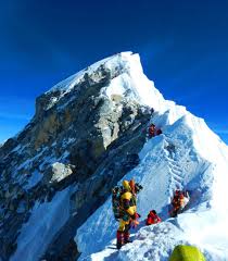
Mount Everest, locally known as Sagarmatha in Nepali and Qomolangma in Tibetan, is the highest mountain on Earth, standing at an elevation of 8,848.86 meters (29,031 feet), as confirmed by Chinese and Nepali authorities in 2020. The summit of Everest marks the border between Nepal and China, situated in the Mahalangur Himal sub-range of the Himalayas.

This iconic mountain attracts numerous climbers, including seasoned mountaineers. There are two primary routes to the summit: the southeast route from Nepal, also known as the "standard route," and the north route from Tibet. Despite not being the most technically challenging climb, Everest poses significant dangers such as altitude sickness, extreme weather, and hazards like avalanches and the Khumbu Icefall. As of May 2024, 340 climbers have died on Everest, with over 200 bodies still on the mountain due to the perilous conditions.

Climbers typically start their ascent from base camps located above 5,000 meters (16,404 feet). On the Nepalese side, climbers usually fly into Kathmandu, then Lukla, and trek to the South Base Camp, whereas on the Tibetan side, most drive directly to the North Base Camp. The climb from Lukla to the summit involves an elevation gain of about 6,000 meters (19,685 feet).

The first recorded attempts to summit Everest were made by British mountaineers in the early 20th century, with the first successful ascent achieved by Tenzing Norgay and Edmund Hillary in 1953 via the southeast ridge. The mountain's name was proposed by British Surveyor General of India, Andrew Waugh, in honor of his predecessor, Sir George Everest, despite Everest himself opposing the honor.

Everest's Nepali name, Sagarmatha, means "goddess of the sky," while its Tibetan name, Qomolangma, translates to "holy mother." Both names reflect the cultural and spiritual significance of the mountain to the local communities.

Geology of Mount Everest

Mount Everest is composed of three main geological formations, separated by low-angle faults, also known as detachments. These formations are the Qomolangma Formation, the North Col Formation, and the Rongbuk Formation. They have been thrust southward over each other from the summit to the base.

Qomolangma Formation:

  • Extends from the summit to the top of the Yellow Band, around 8,600 meters above sea level.

  • Consists primarily of grey to dark grey or white Ordovician limestone, interlayered with dolomite and siltstone.

  • Contains microscopic fragments of ancient sea creatures such as crinoids, trilobites, and ostracods.

  • Features a 60-meter-thick thrombolite bed near the summit, formed by cyanobacteria in shallow marine waters.

  • The Qomolangma Detachment is a key fault separating this formation from the underlying Yellow Band, showing significant deformation.

North Col Formation:

  • Spans from 7,000 to 8,600 meters in elevation.

  • The upper part, known as the Yellow Band, is distinguished by its yellowish-brown weathering and contains marble and schist.

  • Below the Yellow Band, the formation consists of interlayered schist and phyllite.

  • The lower part features biotite-quartz schist and other metamorphic rocks, derived from ancient deep-sea sediments.

  • The base of this formation is marked by the Lhotse detachment fault.

Rongbuk Formation:

  • Underlies the North Col Formation and forms the base of Mount Everest, below 7,000 meters.

  • Composed of high-grade metamorphic rocks like schist and gneiss, intruded by leucogranite sills and dikes.

  • These leucogranites were formed about 20 to 24 million years ago during the subduction of the Indian Plate.

  • The formation processes involved deep burial, heating, and partial melting during the collision of the Indian and Asian plates.

Mount Everest itself has risen through the faulting of sedimentary and metamorphic rocks over the continental crust of the Indian Plate during the Cenozoic collision of India with Asia. The Qomolangma and North Col formations consist of marine sediments accumulated on the Indian continental shelf, which were subsequently deformed and thrust upward during the collision. The Rongbuk Formation represents high-grade metamorphic and granitic rocks, formed at great depths and later pushed to the surface. Mount Everest continues to rise by approximately 2 millimeters per year due to ongoing geological processes.

This comprehensive understanding of Everest's geology highlights the complexity and dynamic nature of the Earth's crust in this region.


Features & Services
  • Everest Base Camp Amenities
  • Trekking Routes Facilities
  • Helicopter Rescue Services
  • Guides & Support
  • Climbing Gear & Equipment
  • Permit Offices
  • Altitude Sickness Clinics
  • Wildlife & Flora
  • Geographical Formation
  • The Death Zone
  • Extreme Weather

Opening Hours

  • Sun 19 Jul, 2026 6 AM - 5 PM
  • Mon 20 Jul, 2026 6 AM - 5 PM
  • Tue 21 Jul, 2026 6 AM - 5 PM
  • Wed 22 Jul, 2026 6 AM - 5 PM
  • Thu 23 Jul, 2026 6 AM - 5 PM
  • Fri 24 Jul, 2026 6 AM - 5 PM
  • Sat 18 Jul, 2026 Closed - Closed
Close

Location

Leave a Review
NA Ratings Based on 0 reviews
to post Review.

Sign In